

Newsletter no. 6
Nature-based Solutions for Demonstrating Climate-Resilient Critical Infrastructure
Telespazio UK WP2 contribution to Nature Demo
How structural health of critical infrastructures can be measured to quantify their exposure from natural hazards exacerbated by climate change to contribute to risk calculations?
As climate disruptions become more frequent and intense, the resilience of Europe’s infrastructure is crucial as it supports economic flows, human well-being, and social stability throughout the continent. However, this challenge provides a historic opportunity to revolutionise infrastructure by integrating it with nature. The Nature-Based Solutions for Demonstrating Climate-Resilient Critical Infrastructure (NATURE-DEMO) project creates, validates, and spreads nature-based solutions (NbS) for protecting infrastructure against climate threats. It covers critical sectors (e.g. transport and energy) and engages an alliance of infrastructure owners, scientists from industry and academia, and public authorities.
One of the NATURE-DEMO objectives is to develop a digital decision support platform aimed at enhancing the implementation of Nature-based Solutions. Telespazio UK has worked on asset and regional structural health monitoring improvements that will support the decision-making by providing information derived from remote sensing techniques, specifically satellite and drone data.
Satellite imagery enables large-scale, continuous observation over extended areas, providing valuable insights into environmental conditions, infrastructure, and land use. Drones, on the other hand, offer flexible, high-resolution, and site-specific data collection, allowing for frequent inspections and rapid responses to emerging issues. Together, these technologies create a complementary approach: satellites deliver broad context, while drones provide detailed precision. The use of both source of data provides stakeholders with actionable insights that facilitate informed decision-making regarding climate adaptation measures.
Regarding satellite data, Telespazio UK work focuses on the use of Interferometry SAR and specifically in Persistent Scatters Interferometry (PSI). Telespazio UK that uses PSI data to generate Red-Amber-Green (RAG) alerts on assets of interest and these alerts can become more granular when future projections of infrastructure displacements using time series and climate models are added into the calculations.
The first tool, named Satellite Structural Health Monitoring, ingests high resolution PSI and a 3D Building Information Model to generate detailed RAG alerts. The second tool, named Linear Asset Structural Stability, ingests medium resolution PSI data from the European Ground Motion Service (EGMS) to generate RAG alerts over extended assets. Both tools have also the capability to generate alerts based on the forecasted behaviour of the asset thanks to a ML model implemented for the forecasting of displacement in time series from PSI data.
On the other hand, the company CATEC specialised in drone surveys contributes with the integration of Unmanned Aerial Systems (UAS) into environmental monitoring processes significantly enhances the evaluation and management of Nature-based Solutions (NbS) aimed at protecting critical infrastructure. These platforms offer varying capabilities in terms of endurance, payload capacity, and sensor integration, enabling flexible deployment across demonstration sites. The onboard payloads such as multispectral cameras for vegetation indices, thermal sensors for heat mapping, LiDAR systems for topographic modelling, and high-resolution RGB cameras, together provide a valuable environmental assessment framework.
Satellite Structural Health Monitoring (S-SHM) Tool
The goal of the tool described and brought by TPZ UK as background IPR to generate a Red-Amber-Green (RAG) alerts over the different elements of a Building Information Model (BIM) or 3D representation of a critical infrastructure.
Different levels of alerts are raised in correspondence with the datasets of motion observed near or on each BIM element. The Structural Health Monitoring (SHM) BIM based alerting system tool uses an algorithm developed by Telespazio UK named Satellite-SHM (S-SHM), which is mainly based on two sets of data:
- Dynamic site data, provides the motion observed on the infrastructure and its surroundings. This data is mainly from satellites, which justify the name of the algorithm:
-
- PSI data, which can provide observed past and ongoing motion using archive and new satellite acquisitions. In addition, thanks to the time series forecasting developed in this project, this data also provides information on the forecasted displacement. Optional In-situ sensors data, if available, which can provide information on past motion although its main functionality is the possibility to deliver data in real time (e.g. GNSS sensors)
-
- Static site data, provides information on the infrastructure as follows:
-
- BIM, including geometric and structural information
- Motion thresholds for the different infrastructure elements stated at the design phase ideally. These thresholds can be included in the BIM.
-

Schema of the S-SHM tool
These two datasets are combined and linked, and RAG alerts are raised for each BIM element, see schema beside.
Linear Asset Structural Stability (LASS) Tool
The goal of the Linear Asset Structural Stability (LASS) algorithm is to generate RAG alerts over linear assets exploiting all the information provided by a PSI database, which can be EGMS (European Ground Motion Service) or any other PSI source. Interpretation of the PSI results and their application to specific assets for structural stability monitoring is a key step in providing information in an easy-to-use format.
Belo a schema of the LASS tool is shown. There are two sets of inputs: dynamic site data, which gives information on the displacement on the asset; and static site data, which provides the location of the asset to be analysed and also a set of thresholds to be used in the generationof the RAG alerts.
The LASS algorithm is divided into three modules: Datasets preparation, PSI time series deep analysis and evaluation, and linear asset RAG classification.
The first step of the dataset preparation is to ingest two vector datasets:
-
- Linear asset dataset - this contains the location of the asset and specific asset information.
- PSI Dataset - containing measurement point location, time series of displacement and annual velocity.
After data reading, the algorithm splits the linear asset into smaller segments with a defined length (e.g. 100m), although end sections of the assets may vary slightly. The segment length defines the granularity of the algorithm results and can be adapted to the area of study. In order to assess the stability of each segment, the PSI measurement points within a buffer (e.g. 10m buffer) of each segment are used.
The next step is to analyse in detail the information provided by all the measurement points linked to each linear asset segment. Each of these points contains a time series describing its motion during the period of analysis. In order to understand the stability of the linear asset, this time series needs to be analysed in detail.
The generation of alerts algorithm works in the same way than in S-SHM. It is focused on the analysis of:
-
- Accumulated Displacement, and
- Recent Mean Displacement
The three parameters above are computed and recorded for each measurement point and linked to the nearest linear infrastructure segment.
Once the displacement near each linear infrastructure segment is analysed, the segments are classified in Red-Amber-Green. For this classification, two different thresholds are considered for each parameter: the comfort and the safety thresholds. A segment is classified as Green when all the three parameters are below the comfort thresholds which indicates the linear asset is stable. A segment is classified as Amber when any of the parameters exceed the comfort thresholds and are below the safety one, which indicates a cause for concern. Finally, a segment is classified as Red when one of the parameters exceeds the safety thresholds, which indicates requirement of immediate inspection.

Schema of the LASS tool
In summary, these satellite data based methods aim to assess the structural health of assets using S-SHM and infrastructures using LASS. They provide structural measurement data (surface movement) and contributes to the physical risk assessment of the structure at local level with high resolution and regional level with medium resolution. High resolution is provided by satellites such as CosmoSkymed imaging with radar at 3m pixel resolution and integrating the measurements in the BIM of the structure and Sentinel-1 at 10m pixel resolution for large coverage of linear infrastructures. In addition, both methods can be used not only to measure the structural health at one point in time but study the historical evolution of the structural behaviour opening the possibility to correlate damages and trends to specific climate or other dynamic events. This scalability allows to use both products to assess the structural health prior and post interventions at different scales according to the size of the infrastructure allowing periodic updates on the measurements.
The project will inform on the implementation of S-SHM and LASS models for two demonstration sites: Gschliefgraben landslide and Gradaščica River in SW of Ljubljana inclusing monitoring data updates after the implementation of NbS.
About Telespazio UK
With a pedigree in space technology stretching back nearly 50 years Telespazio UK (TPZ UK) is an experienced consulting, technology, engineering and space services development business. A subsidiary of Telespazio S.p.A in Rome (joint-venture between Leonardo and Thales), TPZ UK has built its first-class reputation by exploiting technology developments in Earth Observation and satellite navigation & communications, pioneering innovative services for customers across institutional, defence & security and commercial markets..
As a leader in satellite systems, applications and geo-information, TPZ UK ensures the clients receive the best advice, support and management. The domain experts specialise in earth observation, navigation, telecommunications, instrument, payload and ground segment systems, as well as software and downstream application development enabling commercial markets to benefit from space data derived solutions. TPZ UK develops Geospatial and EO applications to support the changing world, providing new insights and helping improve decision making with reliable data, for example, applications that can monitor critical infrastructure or extreme climatic events.
Consortium Meeting, 17-19 November 2025, Vienna
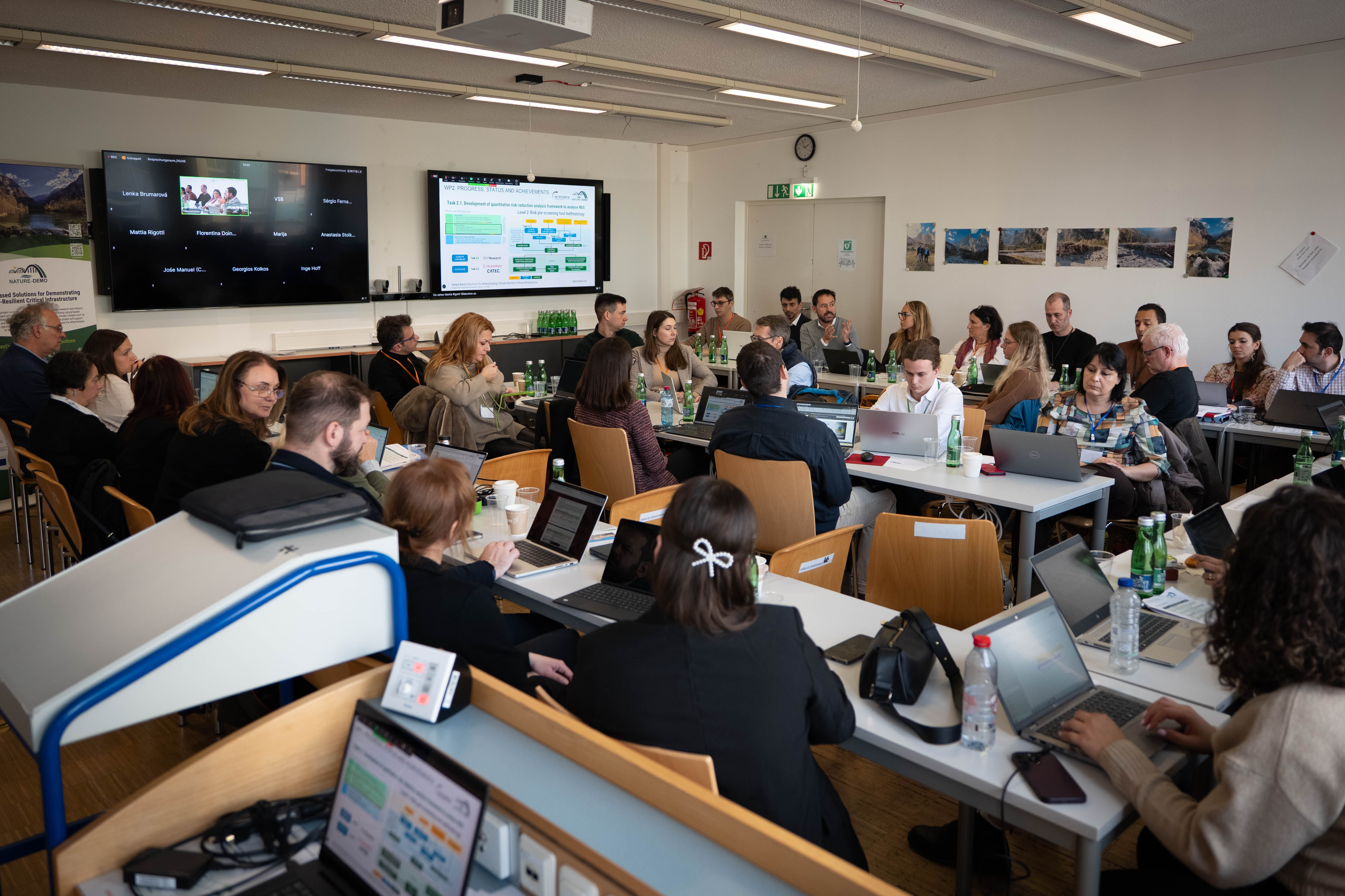
The NATURE-DEMO project continues to make excellent progress, and the consortium meeting held in Vienna in 17-19 November 2025 provided partners with an opportunity to review achievements, discuss current challenges, and define directions for the next phase of implementation.
During the discussions, partners reviewed the project’s progress over the first year and a half, covering research activities, the development of digital tools, planning activities at demonstration sites, and strengthening communication strategies. The importance of collaboration between teams and the role of an integrated approach in developing nature-based solutions was highlighted.
Participants also discussed collaboration with external experts and how their experience contributes to improving project outcomes, particularly in risk assessment, climate resilience, and integrating solutions into decision-making processes.
The Vienna meeting marked an important step in consolidating the project’s strategic directions and preparing activities for the coming months. The consortium will continue working on developing the digital platform, documenting demonstration sites, engaging stakeholders, and promoting nature-based solutions at the European level.
Key Achievements (M1–18)
WP1
- Completed core methodologies (T1.1–T1.3) and deliverables
- Conducted stakeholder sessions and field visits
- Advanced geospatial modelling with IBM Prithvi
WP2
- Finalised theoretical frameworks
- Digital Support Platform under development (50%)
- Indicator system (risk, CAPEX/OPEX, structural stability) validated
WP3
- Conceptual NbS designs for each demo site
- KPIs aligned to monitoring needs
- Preparation for implementation and permitting initiated
WP6
-
- Strengthened dissemination and outreach actions
- Prepared plan for 2027 NbS Conference
- Structured educational and training outputs
Expert Panel Insights
- NbS requires robust evidence to compete with grey infrastructure
- Policymakers need clearer regulatory pathways
- Multi-hazard and climate projections are essential for planning
- Long-term monitoring is critical for scaling NbS
Next Steps (M19–36)
- Completion of Digital Support Platform
- Roll-out of capacity building and training
- Demo-site technical preparation and stakeholder engagement
- Alignment of exploitation and dissemination strategies
Conclusion
The Vienna meeting marks a transition toward operational implementation. With methodologies in place and digital tools advancing rapidly, NATURE-DEMO is entering a decisive phase focused on real-world impact and collaboration with regional and European stakeholders.


NATURE-DEMO Project Highlights
The NATURE-DEMO project has been actively involved in several key events, showcasing its commitment to nature-based solutions for climate-resilient infrastructure:
Driving Urban Resilience: NATURE-DEMO Stakeholder Consultation in Brașov
Our partner, Propark Foundation for Protected Areas (PPK), recently hosted a successful stakeholder consultation meeting for the NATURE-DEMO Demo2 site in Brașov, Romania. This event was a crucial part of our engagement process (WP3, Task 3.2), dedicated to devising our Living Labs and co-designing effective nature-based solutions (NbS).

Seminar: Building Resilient Futures: Nature-Based Solutions & Multi-Hazard Risk Management
This hybrid seminar, held on September 19, 2025, was an exciting opportunity to hear from experts who are at the forefront of developing innovative solutions for enhancing the resilience of infrastructure and communities. Dr. Mohamed Eldessouki, Coordinator of the NATURE-DEMO project, and Dr. Mariantonietta Morga, Senior Lecturer in Civil Engineering at ARU, shared their groundbreaking research and insights.

NATURE-DEMO Project Presents Innovative Solutions at EUROSTRUCT 2025
At the 3rd EUROSTRUCT 2025 Conference in Dublin, the NATURE-DEMO project team, including Maria de Faragofrom Telespazio UK, presented its commitment to enhancing infrastructure resilience through Nature-Based Solutions (NbS), showcasing decision-making frameworks and the integration of satellite monitoring (InSAR) to validate NbS effectiveness against climate hazards.

BOKU at EuroStruct 2025: Bridging Reliability and Sustainability in Infrastructure Engineering
BOKU is pleased to share its active participation at the 3rd EuroStruct Conference, “EUROSTRUCT 2030: Shaping Europe’s Future in Innovation and Sustainability”, held in Dublin from 2–5 September 2025. During the event, Professor Alfred Strauss, a Structural Engineering expert at BOKU and co-initiator of EuroStruct, delivered a high-impact presentation addressing one of today’s most pressing challenges: bridging the gap between reliability and sustainability in infrastructure engineering.

NATURE-DEMO at the Fire Protection 2025 Conference
The NATURE-DEMO project, represented by VŠB-Technical University of Ostrava, participated in the 34th Fire Protection Conference in Ostrava, Czech Republic, held on September 10-11, 2025. The conference, titled "Fire Protection 2025: Current Challenges in Fire Protection," opened with a discussion on the country's worst flood situation in history and how we can prevent and adapt to such events with nature-based solutions.

NATURE-DEMO Participates in Germany’s Week of Climate Adaptation 2025
The NATURE-DEMO project, represented by the German Centre for Rail Traffic Research (DZSF) and partner alchemia-nova (ANRI), engaged in the German "Week of Climate Adaptation 2025" by hosting two webinars (September 15 and 19) to share insights on using Nature-Based Solutions for climate-resilient infrastructure.

NATURE-DEMO at the 13th International Conference on Environmental Engineering and Management
Our team had the pleasure of participating in the 13th International Conference on Environmental Engineering and Management (ICEEM 13), held in Iași, Romania, from September 17–20, 2025, at the Gheorghe Asachi Technical University of Iași. We presented the paper titled, “Sensor-based assessment of green infrastructure strategies for air pollution control in urban areas.”

Strengthening Climate Resilience: NATURE-DEMO and ARCADIA Collaboration in Brașov
On November 5, 2025, the NATURE-DEMO project participated in a significant workshop organized by the ARCADIA Project and ADR Centru, hosted at the Transilvania University of Brașov. The event served as a vital platform for cross-regional and cross-project knowledge exchange, focusing on accelerating the adoption of Nature-Based Solutions (NbS) for climate adaptation.

Knowledge Exchange: NATURE-DEMO Presented at VSB-TUO's University Journal Club
On November 24, 2024, the NATURE-DEMO project was highlighted at the University Journal Club hosted by our partner, VSB – Technical University of Ostrava (VSB-TUO). This event was a key activity in our scientific collaboration strategy, focusing on sharing high-level research within the academic community and with external innovators.

NATURE-DEMO Partners




















Stay tuned!