Newsletter no. 9
Nature-based Solutions for Demonstrating Climate-Resilient Critical Infrastructure
We're excited to bring you the latest news and progress from the NATURE-DEMO Project: Nature-Based Solutions for Climate-Resilient Infrastructure
Our August 2026 newsletter is packed with updates on our efforts to advance nature-based solutions (NbS) for critical infrastructure. As physical implementation gets underway across our demonstrator sites in Brașov, Zvolen, and Globočica, this issue highlights key field progress, ongoing monitoring efforts, academic contributions from the University of Rostock, and our latest project publications
Here's a glimpse of what's inside:
-
About University of Rostock (UROS)
-
Field Progress at DEMO 2: Brașov, Romania
-
Field Progress at DEMO 4: Zvolen, Slovakia
-
DEMO 5: Globočica, North Macedonia — From Design to the Ground
-
Publications
1. About University of Rostock (UROS)
The University of Rostock's Department of Civil Engineering sits within the Faculty of Agricultural and Environmental Sciences, which is a placement that gives the department an unusual head start on questions like resource-efficient construction and building with renewable materials, and that keeps its degree programmes closely interwoven with Environmental Engineering. What sets the Rostock programme apart, though, is its focus on the digital transformation of construction, and its cross-institutional cooperation with Hochschule Wismar under the BLU network for engineering education in construction, landscape and environment.
Within NATURE-DEMO, UROS leads Task 2.4, the development of the project's Digital Decision Support Tool (DST) that is the platform featured in earlier newsletters that now runs live risk-assessment workflows for infrastructure managers across the demonstrator sites. UROS also leads Work Package 5, "Mainstreaming Nature-based Solutions", including Task 5.1, which prepares the replication of NATURE-DEMO's solutions in new regions beyond the five original demonstrators.
Two professorships anchor this contribution.
1.1 AI for Sustainable Construction
The AI for Sustainable Construction group teaches the department's foundations programming and databases, CAD and Building Information Modelling (BIM) as well as advanced coursework spanning machine learning, digital twins, AR/VR, and construction robotics. This professorship is the home of NATURE-DEMO's DST, applying these same AI methods to turn climate-hazard data and NbS suitability criteria into a working decision-support platform for infrastructure managers.
1.2. Concrete Structures and Infrastructures Engineering
Concrete Structures and Infrastructures Engineering (Massivbau) covers structures and components built from reinforced concrete, prestressed concrete, and masonry which is a central pillar of civil engineering practice. Its research spans structural concepts, material-appropriate modelling and construction, the combination of traditional and innovative materials for sustainable building, and safe, economical structural design. It is one of four civil engineering professorships established under the BLU concept for cross-site engineering education in construction, landscape and environment.

Figure 1. The developed Decision Support Tool by the University of Rostock (UROS)
1.3 Hanse Sail Rostock 2026 & Science@Sail
From 6–8 August 2026, Rostock hosted the 35th Hanse Sail which is one of Europe's largest maritime festivals, drawing hundreds of thousands of visitors to the city harbor and along the Warnow to Warnemünde for tall ships, traditional sailing vessels, and a full programme of stages, markets, music, and fireworks.
As part of Science@Sail, the University of Rostock joined regional research institutions to present their work to the public through exhibitions, talks, and a family programme running into the evening. On 6 August, Prof. Panagiotis Spyridis presented NATURE-DEMO to festival visitors, introducing the project's approach to protecting critical infrastructure against climate hazards through nature-based solutions, and showcasing its results to date: the NbS Catalogue, the Digital Decision Support Tool, and progress across the five demonstrator sites.
Professor Spyridis explained the concepts and achievements of Nature-Demo project to the audience.
2. Field Progress at DEMO 2: Brașov, Romania
The DEMO 2 case-study area covers public green spaces in established residential districts and dense central areas of Brașov, where existing green patches are small, often decades old in design, and lack a coherent landscape approach. NATURE-DEMO treats these spaces as both part of the solution and as a distinct layer of urban green infrastructure, applying NbS such as native and climate-resilient plant species, greater species diversity, vertical stratification of vegetation layers, mulching and organic-matter retention, and higher planting density to deliver local social and ecological benefits.
Implementation has now reached 50%: all plants, trees, and shrubs have been planted, and the different planting areas have been clearly defined using biodegradable edging. The next steps are mulching, along with installing ground-cover fabric and gravel.
In parallel, Propark began a new collaboration with the Romanian Architects' Association, running workshops for architects on planning and designing green spaces as a core part of green infrastructure under climatic stress. The first workshop has already taken place, with a second scheduled for autumn 2026; participants are also introduced to the Ecolandscaping digital tool, which lets them evaluate green spaces from a biodiversity perspective which is a key indicator of a healthy urban environment.
Figure 3. Propark began a new collaboration with the Romanian Architects' Association, running workshops for architects on planning and designing green spaces as a core part of green infrastructure under climatic stress
3. Field Progress at DEMO 4: Zvolen, Slovakia
Following the launch of WP4, implementation is now underway across DEMO4's three localities near Zvolen, moving from design into physical works and monitoring.
3.1 At the E77/Zvolen Bypass Corridor, vegetation clearance within the high-voltage power-line protection zone is scheduled for August/September 2026, creating a roughly 450m × 10m fire-protection strip through wildfire-oriented forest management at the road-forest-powerline interface.
3. 2 Hanse Sail Rostock 2026 & Science@Sail
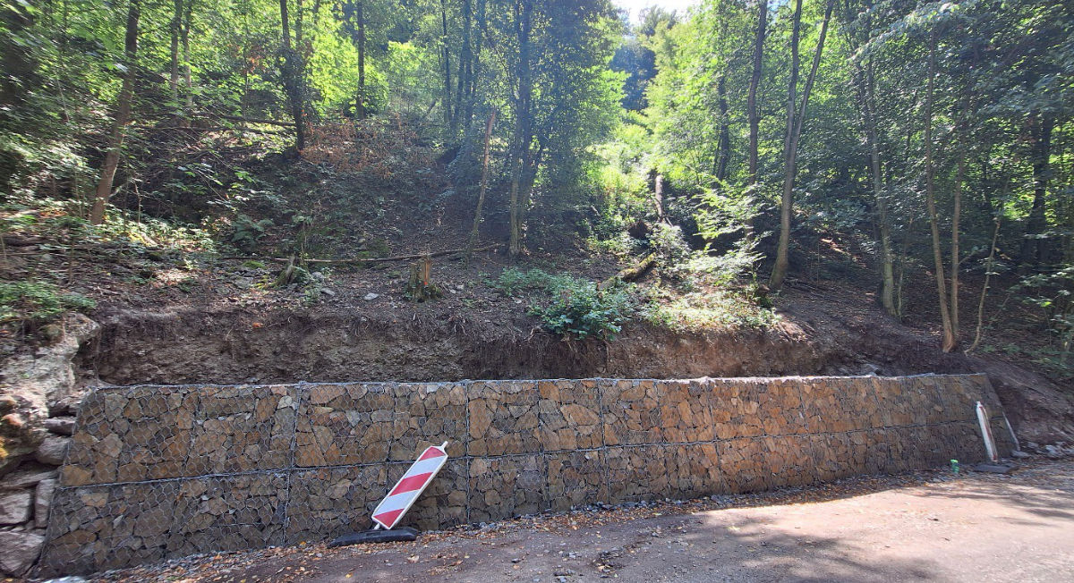
At the Pusty hrad slopes, three stone-filled gabion retaining structures and associated drainage channels are under construction to stabilize slope sections and route surface runoff beneath the road toward the Hron River which is supported by the Municipality of Zvolen and its forest enterprise.
Ongoing gabion construction at the DEMO4 Pusty hrad slopes locality.
3. 3 Hanse Sail Rostock 2026 & Science@Sail
At Neresnica, vegetation has been cleared from a cascade of seven existing check dams, with deepening of selected dams planned for September 2026; around 12 wooden cross-drains will follow along the adjacent forest road to route runoff into the cascade.
Cleared check dams at the DEMO4 Neresnica locality.
An integrated monitoring system combining fixed IoT sensors, UAV LiDAR, UAV multispectral surveys, and field observations is being developed in parallel, tracking meteorological conditions, soil moisture, slope movement, water level, vegetation, fuel structure, erosion, sediment accumulation, and the condition of the implemented NbS.
4. DEMO 5: Globočica, North Macedonia — From Design to the Ground
4.1 This Issue's Spotligh
Of the five NATURE-DEMO demonstrators, Globočica has waited longest for its moment in this newsletter and this quarter it delivers the project's most complete before-and-after story yet: a stakeholder workshop, a full week of on-site construction, and a first round of post-implementation drone monitoring, all within six weeks.
4.1 This Issue's Spotligh
Of the five NATURE-DEMO demonstrators, Globočica has waited longest for its moment in this newsletter and this quarter it delivers the project's most complete before-and-after story yet: a stakeholder workshop, a full week of on-site construction, and a first round of post-implementation drone monitoring, all within six weeks.
4.2 The Site
DEMO 5 site in the Alpine biogeographic region of western North Macedonia, within the catchment of the Black Drim Hydroelectric System, the Shpilje and Globočica dams, together with their access roads and supporting infrastructure. As the largest hydroelectric system in the Black Drim river basin, it is a key source of electricity for the country, with its output affecting around one million people. In recent years the region has seen increasingly severe precipitation and drought events attributable to climate change, and in their aftermath the critical infrastructure has been left directly exposed to landslides and rockfalls which is the risk this demonstrator is designed to address.
4.3 Stakeholder Engagement
On 17 February 2026, IZIIS convened a stakeholder workshop bringing together representatives from municipalities, public enterprises, the private sector, and NGOs to discuss the site's risk assessment and the proposed Nature-based Solutions.
Feedback from participants underlined both the environmental value of the proposed measures and the importance of protecting the infrastructure itself, confirming alignment between the technical design and local priorities before construction began.
4.4 Implementation on the Ground: 6–13 March 2026
Following the workshop, IZIIS carried out on-site implementation over one intensive week. The treated area covers approximately 10,000 m² of steep, rocky terrain with slopes of 30 to 35°, with only shallow topsoil to work with. Four complementary NbS measures were installed together as an integrated slope-stabilization system:
- ~2,500 trees that are mainly Black Pine and Tamarisk, planted for long-term reinforcement through root development
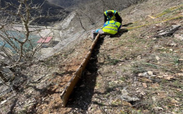
- Wooden log fences to reduce surface erosion and intercept smaller rockfall events
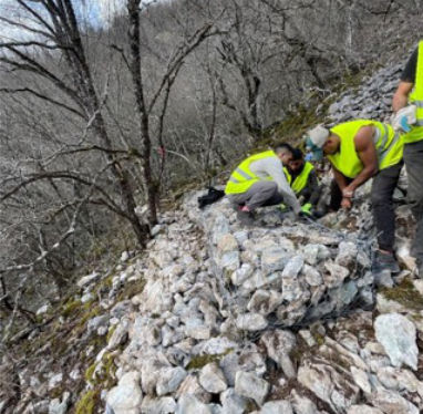
- Vegetated gabion barriers, built from local rock, to improve structural stability of the slope
- Vegetated erosion-control blankets to protect exposed soil and support vegetation establishment
Together, these combine ecological restoration with physical slope protection are the root systems for the long term, structural barriers for the near term.
4.5 Monitoring the Results
On 25 March 2026, IZIIS and CATEC carried out a UAV drone survey to document post-implementation site conditions, giving the team a clear baseline of the treated slope to track vegetation and terrain development going forward. This work sits at the intersection of several work packages: implementation and monitoring link directly to WP3, WP4, and WP5, while all collected data is managed under WP7's quality and data management framework.
4.6 What's Next
The coming months bring a fuller picture of how the site is responding:
- A second UAV monitoring campaign during the growing season
- The first tree survival assessment
- Installation of the IoT monitoring system
- Completion of the site's operational manual
- Continued monitoring of erosion, biodiversity, and overall NbS performance
5. Publications
Two papers from the University of Rostock's NATURE-DEMO team advance the project's methodological toolkit this quarter.
5.1 "Comparative Evaluation of Graph Attention Networks and Physics-Informed Multi-Layer Perceptrons for Urban Pluvial Flood Surrogate Modelling: A Benchmark Study" was accepted for presentation at the 37th Forum Bauinformatik (FBI 2026), taking place in Rostock this autumn. The paper builds a high-resolution flood simulation of a Rostock neighborhood to study how green infrastructure changes flood outcomes during heavy rainfall. Starting from a static baseline of the neighborhood’s existing green infrastructure and city structures (such as, streets, rivers, and buildings taken from OpenStreetMap), the study adds three types of new green infrastructure, bioswales, green roofs, and permeable pavements, placed across the city within realistic construction parameters. Combined with storms of varying rainfall intensity and duration, this produces a wide set of scenarios spanning different green-infrastructure configurations and storm conditions, each yielding a detailed flood-depth picture of the neighborhood while investigating the surrogate models to learn these patterns.
5.2 "Constrained LLM Reporting for Geospatial Climate Risk: A One-Shot In-Context Framework for Critical Infrastructure" was published in Infrastructures, in the special issue "Nature-Based Solutions and Resilience of Infrastructure Systems." The paper centers on the NATURE-DEMO Decision Support Tool (DST) itself, walking through its three connected analytical tools that take an infrastructure manager from site characterization, through qualitative and then quantitative climate-risk assessment, to matching nature-based and technical mitigation options and examines how the DST turns those results into plain-language reports that non-technical stakeholders can read and trust.
NATURE-DEMO Partners
Stay tuned!